By Outdoor Next Editorial standards
On this page
Location & access
DOC track reference point, not a verified trailhead, entrance or the whole route. Check the official route directions before travel.
Official location informationLocation source
DOC track reference point, not a verified trailhead, entrance or the whole route.
Reference point: -36.17617, 175.42247. WGS84 coordinates retained at the official service's returned precision; decimal resolution is not survey accuracy. Source positional accuracy is not specified.
DOC Maps walking and tramping reference point (WGS84), exact official-page GUID / Department of Conservation. Checked 2026-10-12.
Key facts
- Distance
- Not confirmed on the checked DOC page; see individual route sections
- Walking time
- 15 min | 3 hr return
- Track grade
- Easy
- Location
- Great Barrier Island/Aotea
- Dog access
- No dogs. Other pets on conservation land rules.
Checked against official sources on 8 October 2026. Rules and conditions are set by Department of Conservation — confirm with them before you go.
Route overview
Windy Canyon is a popular walk on Great Barrier Island, offering spectacular views. You can then continue on Palmers Track to the summit of Mt Hobson (Hirakimata).
This DOC directory entry covers Windy Canyon and Palmer's Track to Mt Hobson (Hirakimata) in Auckland, within Great Barrier Island/Aotea. Where DOC groups several walks, times and grades refer to the listed options rather than a single continuous itinerary.
Distance, time and grade
- Distance: Not confirmed on the checked DOC page; see individual route sections
- Walking time: 15 min | 3 hr return
- DOC grade: Easy
Access and alerts
Source checked 2026-10-08. This page is a dated snapshot, not a live track-status report. Check current DOC route information immediately before travelling. An absence of listed alerts does not establish that a route is open.
- Kaiaraara Track closure; First published on 20 March 2023. Last reviewed on 28 March 2026.
Dog access
No dogs. Other pets on conservation land rules.
Description
This is the shortest and easiest of the three paths to the summit.
Windy Canyon
Time: 15 min one way
The climbs numerous steps through the sheer rock faces of Windy Canyon. There are splendid views of Okiwi Basin and Whangapoua Beach and estuary to the north, and Kaitoke and Medlands beaches to the east.
Palmer's Track
Time: 3 hr return
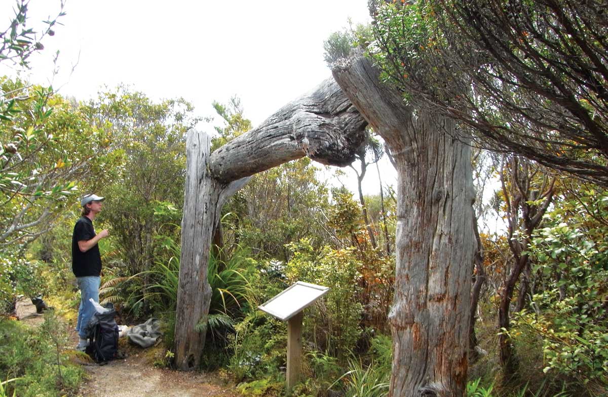
The track follows the ridge offering constantly changing vistas in every direction before climbing steeply to the summit, traversing steep inclines via an impressive system of steps and stairways. Healthy examples of the endemic plant prostrate kānuka can be seen among regenerating forest. On the ridge still stands the ‘wooden horse’, a sturdy H-frame used for winching logs from the eastern slopes up and over the saddle, before sending them plummeting down the other side on their way to the sea.
Mt Hobson (Hirakimata) is the site of several rare species. It is the favoured choice of the tomtit, black petrel and recently re-introduced North Island robin, and is frequented by kākāriki and kākā. The beautiful endemic Great Barrier tree daisy and tiny sun dews like it here as well.
Getting there
The track begins at the top of Whangapoua Hill on Aotea Road.
Know before you go
What to expect
Spectacular views.
Cell phone coverage is average.
Pack well for your day walk. See what to pack for a day walk
Keep to the tracks to avoid damaging rare native plants and disturbing black petrels.
Windy Canyon Lookout Track
The lookout is a natural rock feature which can be slippery with a significant fall risk. We advise taking extra caution in this area.
The walking track can be slippery and uneven in some places. Wear good, sturdy footwear.
There are no water sources on the walking track, we recommend 1L of water per person for this track.
Palmers Track – Lookout to Hirakimata
The track transitions from a ‘Walking Track’ to a ‘Tramping Track’ beyond the Windy Canyon lookout to the Hirakimata Summit.
Sections of this track can be slippery and steep with significant fall risks.
We recommend sturdy hiking boots or hiking shoes with good grip. Sneakers are not suitable for this track.
There are no water sources on the walking track, we recommend 1 - 2L of water per person.
Aotea Track Network
If you or your party are planning to start the Aotea Track from Windy Canyon, we recommend packing to be self-sufficient. To be self-sufficient, pack everything on the overnight and multi-day tramp gear list
The tracks that form the Aotea Track are tramping tracks. We recommend sturdy hiking boots or hiking shoes with good grip. Sneakers are not suitable for the Aotea Track.
There are no water sources on the walking track. We recommend taking 2 - 3L of water per person. There are water supplies at Mt Heale Hut and Kaiaraara Hut.
Check the forecast
The weather on Aotea / Great Barrier Island can be changeable. Be ready for all weather by carrying warm layers, a waterproof raincoat, sun protection and plenty of drinking water.
NIWA Weather: Aotea / Great Barrier Island – Mt Heale Hut
Nature and conservation
Nearing the summit, the track leads into mature forest where logging was too difficult and fires on the lower slopes did not reach. Remnants of an ancient and precious conifer forest, rimu, Kirk’s pine, pink pine and kauri, can be seen here.
Keep an eye out for black petrel. Once widespread on the North Island, breeding colonies of these large, burrow-nesting seabirds are now confined to Great Barrier Island Aotea and Hauturu / Little Barrier Island. The main colony on Great Barrier Island Aotea breeds on the slopes of Mt Hobson (Hirakimata) between October and May each year. Mature birds spend months at sea flying as far as South America and only return to the island to breed. Watch out for them on the road at night.
Sources and reuse
Route descriptions and practical information reproduced from the Department of Conservation, Crown copyright, under CC BY 4.0, subject to DOC's copyright policy. Formatting has been adapted, including flattening page sections; follow the original DOC page for maps, section-specific layout, current notices and linked documents. Outdoor Next is independent and is not endorsed by DOC.
The accompanying photograph is published in DOC's official route gallery with an explicit reuse licence. Its original caption and credit are retained; it does not establish current track conditions.
