By Outdoor Next Editorial standards
On this page
Location & access
DOC track reference point, not a verified trailhead, entrance or the whole route. Check the official route directions before travel.
Official location informationLocation source
DOC track reference point, not a verified trailhead, entrance or the whole route.
Reference point: -37.73554, 175.87317. WGS84 coordinates retained at the official service's returned precision; decimal resolution is not survey accuracy. Source positional accuracy is not specified.
DOC Maps walking and tramping reference point (WGS84), exact official-page GUID / Department of Conservation. Checked 2026-10-12.
Key facts
- Distance
- 5 km return via same track
- Walking time
- 3–4 hr return via same track
- Track grade
- Easy
- Location
- Kaimai Mamaku Conservation Park
- Dog access
- Dogs with a DOC permit for recreational hunting or management purposes only. Other pets on conservation land rules.
Checked against official sources on 8 October 2026. Rules and conditions are set by Department of Conservation — confirm with them before you go.
Route overview
Wairere Falls Track weaves its way through moss covered rocks and tree roots. Large round boulders form natural pools and cascading waterfalls.
This DOC directory entry covers Wairere Falls Track in Bay of Plenty, within Kaimai Mamaku Conservation Park. Where DOC groups several walks, times and grades refer to the listed options rather than a single continuous itinerary.
Distance, time and grade
- Distance: 5 km return via same track
- Walking time: 3–4 hr return via same track
- DOC grade: Easy
Access and alerts
Source checked 2026-10-08. This page is a dated snapshot, not a live track-status report. Check current DOC route information immediately before travelling. An absence of listed alerts does not establish that a route is open.
- Wairere Falls Track closed; First published on 13 June 2025. Last reviewed on 3 September 2026.
Dog access
Dogs with a DOC permit for recreational hunting or management purposes only. Other pets on conservation land rules.
Description
Carpark to lookout
Time: 45 mins one way
Slippery, muddy and rocky section of Wairere Falls Track. See larger (JPG, 202K)Image: Theo Chapman | DOC
From the car park an undulating track crosses large moss-covered rocks and tree roots.
Sections of the track are wet, muddy, and rocky. Sturdy walking shoes with good grip or tramping boots are recommended. Take your time on the rocky, slippery sections of track.
Small wooden bridges take you across the stream at several points, offering lovely views of the water and its cascades.
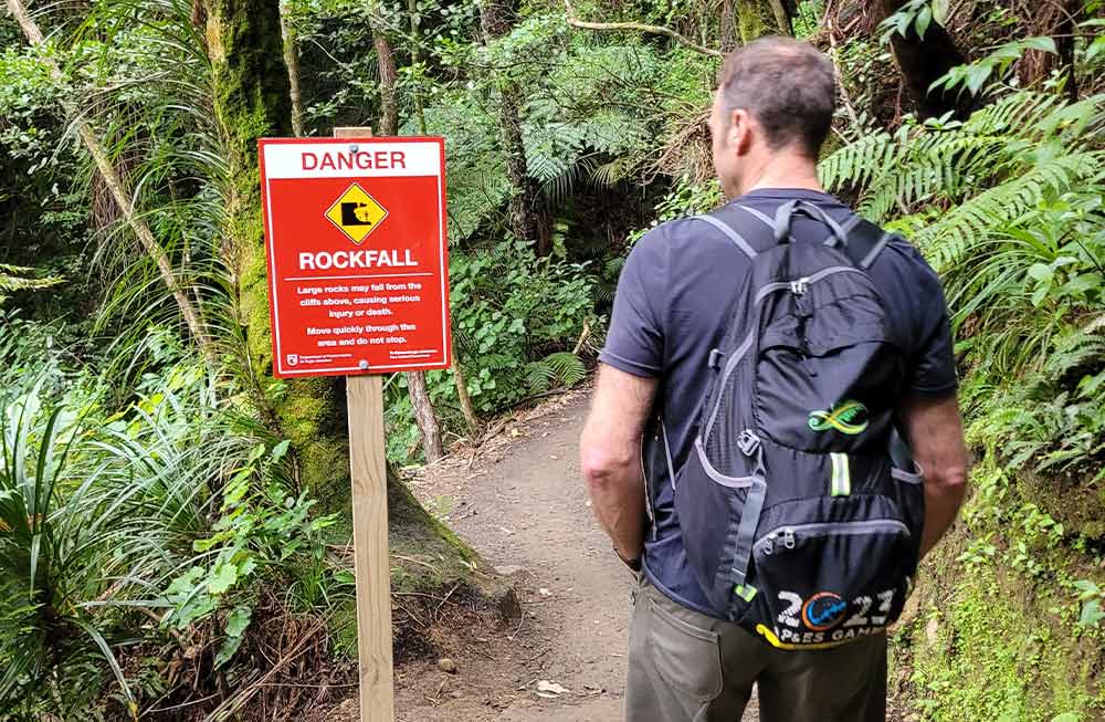
The track passes through rockfall zones, follow the signage and move quickly through these areas. Do not stop.
There is a steady incline up the steps to the base of the cliff, through a grove of nīkau, pūriri and kohekohe. After this you arrive at a lookout platform with a spectacular view of the falls.
Lookout to top platform – very steep
Time: 90 mins one way
Steep stairs on Wairere Falls Track. See larger (JPG, 197K)Image: Theo Chapman | DOC
The track becomes much harder from this point as it climbs further up the hill to the top platform. There are plenty of steps and staircases in the steeper section.
Take your time as you climb to the top of the falls and watch your footing over the rocks and tree roots. Once you reach the top of the climb, the track passes through forest before reaching the falls lookout after about 90 minutes. The viewing platform at the top of the waterfall provides fantastic views of the Waikato valley.
The falls drop 153 metres over the steep escarpment, which is part of the Okauia fault line. Stay away from the edge at the top of the falls. In spring, watch out for the apricot-coloured flowers of the taurepo plant on the rocky valley walls.
Return the same way. Some people take walking sticks as the return walk down hill and steps can be tiring on knees.
Continue on to Wairere Track
From the top of the falls you can access the Wairere Track east to the North South Track. This track is not as well maintained as the climb to Wairere Falls.
Getting there
Wairere Falls Track is on Goodwin Road off Te Aroha-Okauia road, south of Te Aroha.
Know before you go
Be aware of rockfall risks and steep drops
There is a risk of rockfalls on sections of this track. The risk is highest during/after heavy rain, but they can still occur at other times. Rockfalls can cause serious injury or death.
Rockfall risk areas are marked with signs. Move quickly and carefully through these areas, and not stop.
There are also steep drops – keep an eye on children and stand well back. Stay away from the edge at the top of the falls.
Do not use this track during/after heavy rain
There is an increased risk of landslides, rockfalls and flash flooding during/after heavy rain.
Do not use the track during or after heavy rain, or when a severe weather watch or warning has been issued.
Find a weather forecast for Wairere Falls Track here
Find Metservice severe weather watch or warnings here
Find information on yesterday’s rainfall here
The track and surrounding boulders can be slippery
Be aware the track and boulders that border the track can become slippery during or after rain events, in shaded areas, and during the colder months of the year. Remain on the marked track at all times.
To reduce the risk of serious injury or harm:
Take your time when navigating over large rocks or boulders on the track.
Ensure you have secure footing when navigating these areas.
Always be aware of your surroundings.
Water safety
If you plan to enjoy the water, learn how to stay safe when swimming, boating and fishing.
Be prepared for your walk
Expect a steep and rough track with rocky, uneven ground. The track is muddy, wet and slippery in places.
You need to be moderately fit to walk this track comfortably and have sturdy shoes with good grip. Take your time on the rocky, slippery sections of track.
Remember to pack warm clothes, a good raincoat, food and drink, a hat, sunscreen and a first aid kit. Find a full packing list for day walks here.
Know the rules for this area
No dogs or firearms unless you have a permit for hunting. Abseiling and mountain biking are prohibited.
Wasps
Wasps are present in the area, especially in the warmer months. They can become aggressive if disturbed. Avoid nests, cover food and supervise children.
Nature and conservation
The Wairere Falls track takes walkers through a beautiful, diverse range of natural scenery. Besides the spectacular 153 m high falls there are beautiful river falls and cascades, a fine grove of nīkau, pūriri and kohekohe, and an upper section of track takes you through tree ferns and tōtara in native forest.
Sources and reuse
Route descriptions and practical information reproduced from the Department of Conservation, Crown copyright, under CC BY 4.0, subject to DOC's copyright policy. Formatting has been adapted, including flattening page sections; follow the original DOC page for maps, section-specific layout, current notices and linked documents. Outdoor Next is independent and is not endorsed by DOC.
The accompanying photograph is published in DOC's official route gallery with an explicit reuse licence. Its original caption and credit are retained; it does not establish current track conditions.
