By Outdoor Next Editorial standards
On this page
Location & access
DOC track reference point, not a verified trailhead, entrance or the whole route. Check the official route directions before travel.
Official location informationLocation source
DOC track reference point, not a verified trailhead, entrance or the whole route.
Reference point: -35.60069, 173.52727. WGS84 coordinates retained at the official service's returned precision; decimal resolution is not survey accuracy. Source positional accuracy is not specified.
DOC Maps walking and tramping reference point (WGS84), exact official-page GUID / Department of Conservation. Checked 2026-10-12.
Key facts
- Distance
- Not confirmed on the checked DOC page; see individual route sections
- Walking time
- 5 min one way
- Track grade
- Easiest
- Location
- Waipoua Forest
- Dog access
- Dogs with a DOC permit for recreational hunting or management purposes only. Other pets on conservation land rules.
Checked against official sources on 8 October 2026. Rules and conditions are set by Department of Conservation — confirm with them before you go.
Route overview
Visit New Zealand's largest known living kauri tree, Tāne Mahuta, on this short, easy walk suitable for buggies and children. It is open 9 am to 4 pm daily.
This DOC directory entry covers Tāne Mahuta Walk in Northland, within Waipoua Forest. Where DOC groups several walks, times and grades refer to the listed options rather than a single continuous itinerary.
Distance, time and grade
- Distance: Not confirmed on the checked DOC page; see individual route sections
- Walking time: 5 min one way
- DOC grade: Easiest
Access and alerts
Source checked 2026-10-08. This page is a dated snapshot, not a live track-status report. Check current DOC route information immediately before travelling. An absence of listed alerts does not establish that a route is open.
- Helicopter activity near Tāne Mahuta; First published on 1 May 2026. Last reviewed on 2 October 2026.
Dog access
Dogs with a DOC permit for recreational hunting or management purposes only. Other pets on conservation land rules.
Description
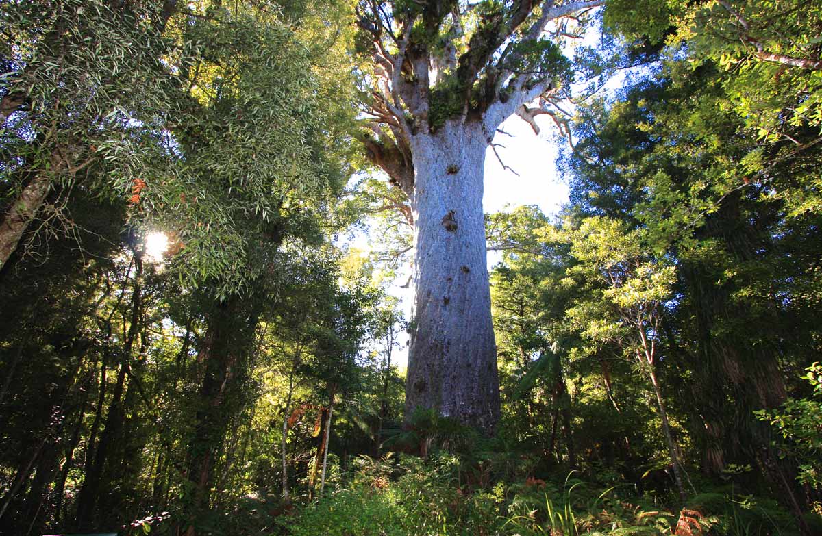
This wheelchair and buggy accessible short walk leads you under cooling shade of the forest canopy to the majestic Tāne Mahuta, New Zealand's largest living kauri tree.
Not far into the walk, a sweeping corner of the track suddenly brings you face to face with the ‘Lord of the Forest’. When you catch your first breathtaking view of this magnificent tree, you'll feel compelled to pause for a while. You can almost feel Tāne Mahuta’s strength and ancient presence, and its overwhelming size makes visitors look like dwarfs.
There is a wooden fence and a seat to view the tree. To get a broader view of Tāne Mahuta, you can move further along the track, which then leads to another viewing platform.
Open 9 am to 4 pm
The gate to the track is locked when the track is closed.
Getting there
The Tāne Mahuta Walk is signposted from SH12, which runs through the Waipoua Forest. The southern township of Dargaville is 65 km away and the northern township of Omapere is 18 km.
The road widens at the Tāne Mahuta car park to accommodate visitor vehicles. There is a picnic area, and toilets located 25 m back from the car park on the opposite side of the road from the track entrance.
Know before you go
Keep to the track at all times.
In strong winds, beware of falling branches.
The gate and toilets are locked over night.
Wheelchair access
Available via the ramp on the left-hand side of the wash station entrance. Once through the gate a brush can be used for cleaning prior to travelling over blue mats placed on the floor.
Ensure wheelchairs are clean prior to entering the wash station.
Nature and conservation
It is very important that you keep to the walking track at all times. Kauri trees have very sensitive surface roots, and foot traffic around the tree endangers their life span.
About Tāne Mahuta
Tāne Mahuta ('Lord of the Forest') is New Zealand’s largest known living kauri tree.
It is thought the first encounter of the tree by Westerners was in the 1920s, by contractors surveying the present SH12 through the forest. In 1928, Nicholas Yakas and other bushmen who were building the road, also came across the big tree Tāne Mahuta.
According to Maori mythology Tāne is the son of Ranginui the sky father and Papatuanuku the earth mother. Tāne was the child that tore his parents' parental embrace and once done set about clothing his mother in the forest we have here today. All living creatures of the forest are regarded as Tāne's children.
Measurements:
Trunk girth: 13.77 m
Trunk height: 17.68 m
Total height: 51.2 m
Trunk volume: 244.5 m³
Sources and reuse
Route descriptions and practical information reproduced from the Department of Conservation, Crown copyright, under CC BY 4.0, subject to DOC's copyright policy. Formatting has been adapted, including flattening page sections; follow the original DOC page for maps, section-specific layout, current notices and linked documents. Outdoor Next is independent and is not endorsed by DOC.
The accompanying photograph is published in DOC's official route gallery with an explicit reuse licence. Its original caption and credit are retained; it does not establish current track conditions.
