By Outdoor Next Editorial standards
On this page
Location & access
DOC track reference point, not a verified trailhead, entrance or the whole route. Check the official route directions before travel.
Official location informationLocation source
DOC track reference point, not a verified trailhead, entrance or the whole route.
Reference point: -41.71626, 172.98449. WGS84 coordinates retained at the official service's returned precision; decimal resolution is not survey accuracy. Source positional accuracy is not specified.
DOC Maps walking and tramping reference point (WGS84), exact official-page GUID / Department of Conservation. Checked 2026-10-12.
Key facts
- Distance
- 40 km one way
- Walking time
- 3 days one way
- Track grade
- Advanced; Expert
- Location
- Nelson Lakes National Park
- Dog access
- Dogs with a DOC permit only. Contact closest DOC office to get a permit. Other pets on conservation land rules.
Checked against official sources on 8 October 2026. Rules and conditions are set by Department of Conservation — confirm with them before you go.
Route overview
The Red Hills Route is a challenging backcountry adventure from Mid Wairoa Hut by the Wairoa River to Red Hills Hut. This track is part of Te Araroa Trail.
This DOC directory entry covers Red Hills Route in Marlborough, within Nelson Lakes National Park. Where DOC groups several walks, times and grades refer to the listed options rather than a single continuous itinerary.
Distance, time and grade
- Distance: 40 km one way
- Walking time: 3 days one way
- DOC grade: Advanced; Expert
Access and alerts
Source checked 2026-10-08. This page is a dated snapshot, not a live track-status report. Check current DOC route information immediately before travelling. An absence of listed alerts does not establish that a route is open.
Dog access
Dogs with a DOC permit only. Contact closest DOC office to get a permit. Other pets on conservation land rules.
Description
This track is part of Te Araroa Trail.
The track starts from Alpine Route. A trip highlight is the unusual geology and plants of the Red Hills area.
Mid Wairoa Hut to Top Wairoa Hut
Distance: 8 kmTime: 4 hr 30 min
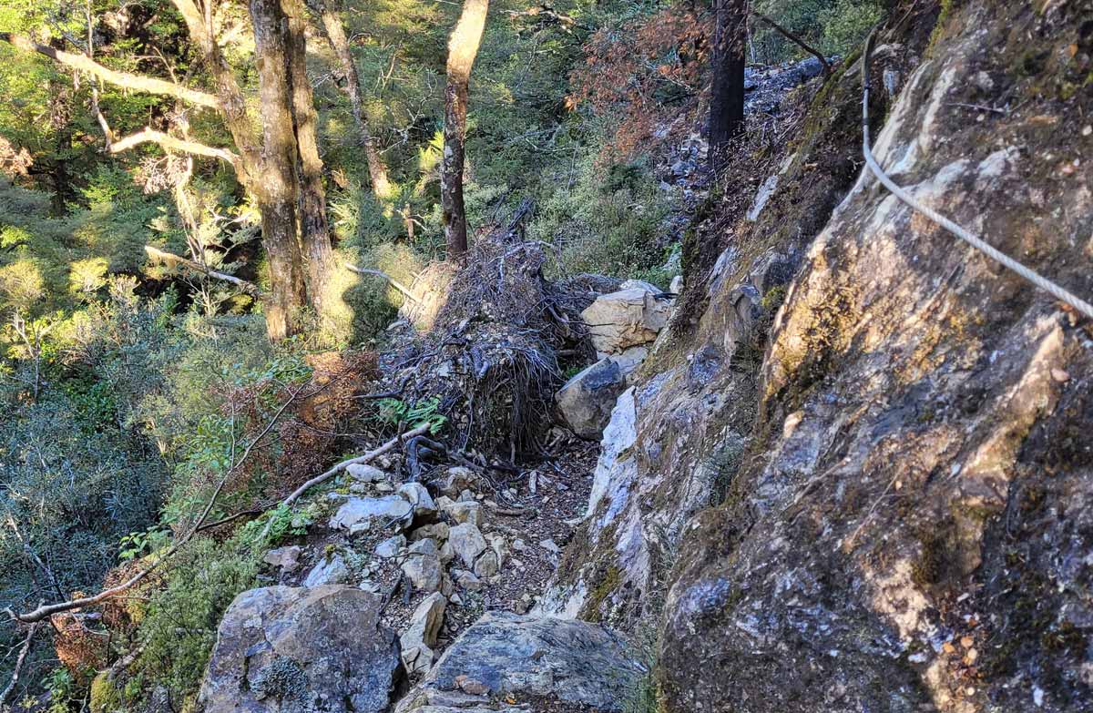
The track from Mid Wairoa Hut follows the river. It involves a lot of sidling, at times on steep terrain, and eight river crossings. In some areas, erosion on the track presents slippery and/or narrow footholds and extreme care should be taken through here.
Some trampers will find this section challenging. It should not be attempted during periods of heavy rain as the river can rise quickly.
Top Wairoa Hut to Hunters Hut
Distance: 12 kmTime: 6 hr
The track leaves Top Wairoa Hut and climbs through alpine vegetation up to Mt Ellis (1615 m). It’s a great place to stop for lunch, with 360-degree views overlooking Tasman Bay and the Red Hills.
The track then descends to the left branch Motueka river. It follows the river, then crosses it (unbridged) and climbs to Hunters Hut.
Hunters Hut to Porters Creek Hut
Distance: 9 kmTime: 3 hr
The track leaves Hunters Hut and sidles in and out of several gullies, following the edge of the Red Hills ultramafic area before reaching Porters Creek Hut.
Porters Creek Hut to Red Hills Hut
Distance: 11 kmTime: 5 hr
The track drops from Porters Creek Hut into Lowther Creek, then climbs up to a low saddle. After that, it sidles down to the right branch of the Motueka River and crosses it (unbridged). The track then sidles and climbs to the Red Hills Hut.
Two track options from Red Hills Hut
Red Hills Hut to SH63
Distance: 7 kmTime: 3 hr
From Red Hills Hut, follow the 4wd road for 5.5 km down to the grassy flats at the bottom. Don’t go over the locked gate as this is private land. Follow the orange triangle markers southwest for another 1.5 km to the Six Mile car park. From the highway, there are signs saying 'Access to Red Hills Route'.
Continue on Te Araroa Trail
From Red Hills Hut you can continue along Maitland Ridge Mountain bike Track. This takes you towards Beebys Knob Road. The track descends off the ridge on Te Araroa Trail to meet Tophouse Road near the Lowther Road turnoff.
The trails around Red Hills and Beebys are shared-use tracks, with trampers and mountain bikers.
More about Beeby's Knob tracks
Getting there
The Red Hills Route starts at Mid Wairoa Hut and ends at SH63.
Many people start the Red Hills Route at the end of the Alpine Route, which finishes at Mid Wairoa Hut.
Nearest road access to Mid Wairoa Hut
Distance: 10 kmTime: 4 hr 30 min
The nearest road access to Mid Wairoa Hut is from Wairoa Gorge Mountain Bike Park. The road end is a 34 km drive via Brightwater up Wairoa Gorge Road. The last 14 km is over a rough gravel road. It is possible to park at the road end, at the first locked gate.
Know before you go
What to expect
The Red Hills Route is a challenging backcountry route, graded as expert level. You can expect:
the track to be unformed, with steep and rough sections and unbridged river crossings. You will need to follow markers, poles and cairns to stay on the route
river crossings to be impassable after rain
freezing temperatures, wind and snow in alpine sections at any time of the year.
To attempt this track, you need to:
have plenty of experience tramping in remote backcountry places and navigating on unformed tracks
know how to cross rivers safely – and be able to judge when it is not safe to cross
have survival skills and the gear you need to be completely self-sufficient.
Gear list
As this is a very remote location with no cell phone reception, you will need a distress beacon.
Multi-day tramp gear list
It's likely you will be delayed during your trip, for example, if you need to wait for river levels to drop before crossing. Pack:
spare food, and an
emergency shelter, for example a tent or fly
These help to make sure you're ready for an extra night out or sheltering while waiting for river levels to drop.
Mountain biking not recommended
While mountain biking is permitted on the track, it is not recommended. The grade is Extreme: Grade 6 and you would likely be carrying your bike more than riding it. There is a high risk of multiple punctures.
Large number of wasps
There are large numbers of wasps in Wairoa Valley between January and April. Pack antihistamines and consider carrying an EpiPen.
Nature and conservation
The track traverses a mixture of beech forest, alpine tussock lands and ultramafic rock. This rock is quite barren, with sparse and stunted vegetation due to the high mineral content.
Situated at the southwestern edge of the Mount Richmond Forest Park, the Red Hills are a unique ultramafic geological area composed of very dense magnesium-rich rocks which have been thrust up at least 10 km or more from below the earth’s crust.
The soils derived from these magnesium-rich rocks are too toxic for tree growth so much of the area is covered in distinctive scrub and tussock.
There is evidence of early Māori occupation with numerous argillite quarries. This ultramafic area runs from Ben Nevis in the north around 20 km south to State Highway 63.
Sources and reuse
Route descriptions and practical information reproduced from the Department of Conservation, Crown copyright, under CC BY 4.0, subject to DOC's copyright policy. Formatting has been adapted, including flattening page sections; follow the original DOC page for maps, section-specific layout, current notices and linked documents. Outdoor Next is independent and is not endorsed by DOC.
The accompanying photograph is published in DOC's official route gallery with an explicit reuse licence. Its original caption and credit are retained; it does not establish current track conditions.
