By Outdoor Next Editorial standards
On this page
Location & access
DOC track reference point, not a verified trailhead, entrance or the whole route. Check the official route directions before travel.
Official location informationLocation source
DOC track reference point, not a verified trailhead, entrance or the whole route.
Reference point: -42.13101, 171.40640. WGS84 coordinates retained at the official service's returned precision; decimal resolution is not survey accuracy. Source positional accuracy is not specified.
DOC Maps walking and tramping reference point (WGS84), exact official-page GUID / Department of Conservation. Checked 2026-10-12.
Key facts
- Distance
- 16 km one way | 17.1 km one way return via same track
- Walking time
- 4-5 hr one way
- Track grade
- Intermediate
- Location
- Paparoa National Park
- Dog access
- No dogs. Other pets on conservation land rules.
Checked against official sources on 8 October 2026. Rules and conditions are set by Department of Conservation — confirm with them before you go.
Route overview
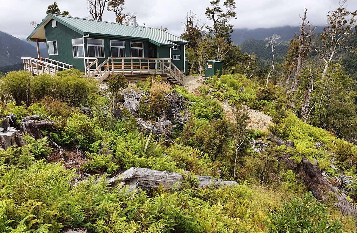
Walk to Pororari Hut for 360 degree views and experience a shorter (overnight) version of the Paparoa Track Great Walk.
This DOC directory entry covers Paparoa Track: Pororari Hut Track in West Coast, within Paparoa National Park. Where DOC groups several walks, times and grades refer to the listed options rather than a single continuous itinerary.
Distance, time and grade
- Distance: 16 km one way | 17.1 km one way return via same track
- Walking time: 4-5 hr one way
- DOC grade: Intermediate
Access and alerts
Source checked 2026-10-08. This page is a dated snapshot, not a live track-status report. Check current DOC route information immediately before travelling. An absence of listed alerts does not establish that a route is open.
Dog access
No dogs. Other pets on conservation land rules.
Description
Walking options
For a 1 night trip, walk to Pororari Hut
For a 2 night trip, walk to Pororari Hut and stay two nights. This gives you time to do the side trip to the northern end of the escarpment.
Track description
From the Pororari River car park, the track passes through lush rainforest with glades of nikau palms. It then climbs through beech forest interspersed with northern rata and sidles through a spectacular gorge. From the upper Pororari River valley, it climbs to Pororari Hut where there are stunning 360 degree views.
Follow the same track back to car park.
Time: 6 hr return
From Pororari Hut the track continues to the emergency shelter on the northern end of the escarpment. This track includes good views before it transitions into alpine bush and the emergency shelter.
Follow the same track back to Pororari Hut.
Fees are charged per person, per night to stay in Pororari Hut. There are no fees to complete a day walk on the track or for entry into Paparoa National Park.
Mountain biking
Time: 2 hr 30 min – 3 hr 30 min one wayDistance: 17.1 km
Time: 3–4 hr one wayDistance: 8 km
Getting there
The track starts from the Pororari River carpark on SH6, 1.2 km north of Pancake Rocks at Punakaiki.
Know before you go
Your safety is your responsibility
Know the Outdoor Safety Code - 5 simple rules to help you #makeithome.
Be prepared for all conditions
Weather in Paparoa National Park is changeable with annual rainfall averaging around 6,000 mm (235 inches). Heavy rain, snow, ice, fog and strong winds are possible at all times of the year, especially on the exposed sections of the track.
You must be well equipped and prepared for all weather conditions and carry warm and waterproof clothing. If the weather becomes severe, stay put in the hut or turn back until conditions improve.
If you are hiking the track in winter, check for snow and ice conditions before you leave and allow extra time. If in doubt, consider changing your trip to another day.
Check Paparoa National Park weather forecast
Some sections of track in the Pororari Valley may become impassable during times of very heavy rainfall. There is also a risk of landslides. There is danger of treefall in extreme wind events. Do not attempt to travel if these conditions occur.
Watch out for Ongaonga (tree nettle)
New Zealand’s native tree nettle, Ongaonga, may be seen in the Pororari Valley. It's sting is painful - don't touch its leaves.
Sources and reuse
Route descriptions and practical information reproduced from the Department of Conservation, Crown copyright, under CC BY 4.0, subject to DOC's copyright policy. Formatting has been adapted, including flattening page sections; follow the original DOC page for maps, section-specific layout, current notices and linked documents. Outdoor Next is independent and is not endorsed by DOC.
The accompanying photograph is published in DOC's official route gallery with an explicit reuse licence. Its original caption and credit are retained; it does not establish current track conditions.
