By Outdoor Next Editorial standards
On this page
Location & access
DOC track reference point, not a verified trailhead, entrance or the whole route. Check the official route directions before travel.
Official location informationLocation source
DOC track reference point, not a verified trailhead, entrance or the whole route.
Reference point: -44.75479, 168.01593. WGS84 coordinates retained at the official service's returned precision; decimal resolution is not survey accuracy. Source positional accuracy is not specified.
DOC Maps walking and tramping reference point (WGS84), exact official-page GUID / Department of Conservation. Checked 2026-10-12.
Key facts
- Distance
- 7 km return via same track
- Walking time
- 4-6 hr
- Track grade
- Expert
- Location
- Fiordland National Park / Milford Road/Milford Sound area
- Dog access
- No dogs. Other pets on conservation land rules.
Checked against official sources on 8 October 2026. Rules and conditions are set by Department of Conservation — confirm with them before you go.
Route overview
Gertrude Saddle includes rocky alpine terrain and should only be attempted by experienced trampers and in good weather. Wet weather, snow or ice create treacherous conditions in any season.
This DOC directory entry covers Gertrude Saddle Route in Fiordland, within Fiordland National Park / Milford Road/Milford Sound area. Where DOC groups several walks, times and grades refer to the listed options rather than a single continuous itinerary.
Distance, time and grade
- Distance: 7 km return via same track
- Walking time: 4-6 hr
- DOC grade: Expert
Access and alerts
Source checked 2026-10-08. This page is a dated snapshot, not a live track-status report. Check current DOC route information immediately before travelling. An absence of listed alerts does not establish that a route is open.
Dog access
No dogs. Other pets on conservation land rules.
Description
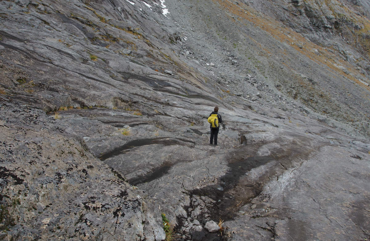
Steep climbs on Gertrude Saddle Route
This is a challenging tramping route requiring tramping and alpine experience, and is not recommended in winter due to avalanche danger.
From the car park, the marked track meanders up the valley through spectacular alpine vegetation. From the head of the valley the route leads up towards the saddle; from this point there are no permanent track markers. Cross the Gertrude Stream below a large, steep waterfall area, about halfway up to Black Lake.
From here, parts of the track are very steep and not suitable for those with limited tramping experience, or a dislike for heights. The track goes up steep rock slabs and is treacherous when wet or frosty - there are steel cables to assist you.
From the head of the valley continue up through the boulders to the saddle. Return the same way.
Breathtaking views of the valley and part of Milford Sound/Piopiotahi can be seen from the Gertrude Saddle. This track provides excellent access to the mountains for experienced climbers.
If there's rain or snow, don't go. You need to cross multiple rivers and steep granite slabs on this route. Check the NIWA weather forecast.
Understand if you are ready for the Gertrude Saddle Route
Watch the NZ Mountain Safety Council’s walk-through video which takes you through how to prepare for this track. Including facilities, key decision points, hazards and typical conditions for the area.
Getting there
This track is reached from the Gertrude Valley carpark, about 98 km along the Milford Road from Te Anau.
Know before you go
Essential safety
Only attempt this track if:
you are fit and experienced – on the route you will have to scramble up steep rock, cross rivers, and avoid hazards by following markers
track and weather conditions are good on the day
you have the right equipment, including a personal locator beacon – see the Day hikes gear list.
This is an alpine route
There are no permanent markers above the bushline, so alpine and navigation skills are essential. Rock cairns placed by trampers mark the route, but be sure to follow your own judgement and use a topographical map.
This is an alpine route and is subject to avalanches after snow.
Weather
Check the Fiordland National Park weather forecast and talk to the staff at the Fiordland National Park Visitor before you go, whenever you go.
After rain there are some creek crossings so expect to get wet feet.
Avoid wet rocks
Wet moss on the rocks and rock slabs of the route is very slippery. It can be treacherous.
Stay safe when crossing rivers and streams
If you plan to cross unbridged rivers or side streams, know how to cross safely and be prepared for if you cannot cross.
Do not cross if the river or stream is flooded, you cannot find safe entry and exit points or are unsure it’s safe. Turn back or wait for the river to drop. If in doubt, stay out.
How to cross rivers safely
NIWA river flow forecasts: View a video of national followed by regional river flows
There may be avalanche danger
Check the avalanche terrain in this area.
Avalanches usually occur from May to November in Fiordland National Park. There can also be avalanches outside this period, if there is still snow coverage.
Check the avalanche danger before you go on the New Zealand Avalanche Advisory.
If you are going into avalanche terrain, always:
Have the relevant avalanche skills and training.
Check the ATES rating and the New Zealand Avalanche Advisory.
Go with a buddy. Both of you should carry and know how to use an avalanche transceiver, a snow shovel and a probe.
Sources and reuse
Route descriptions and practical information reproduced from the Department of Conservation, Crown copyright, under CC BY 4.0, subject to DOC's copyright policy. Formatting has been adapted, including flattening page sections; follow the original DOC page for maps, section-specific layout, current notices and linked documents. Outdoor Next is independent and is not endorsed by DOC.
The accompanying photograph is published in DOC's official route gallery with an explicit reuse licence. Its original caption and credit are retained; it does not establish current track conditions.
