By Outdoor Next Editorial standards
On this page
Location & access
DOC track reference point, not a verified trailhead, entrance or the whole route. Check the official route directions before travel.
Official location informationLocation source
DOC track reference point, not a verified trailhead, entrance or the whole route.
Reference point: -41.76198, 171.45885. WGS84 coordinates retained at the official service's returned precision; decimal resolution is not survey accuracy. Source positional accuracy is not specified.
DOC Maps walking and tramping reference point (WGS84), exact official-page GUID / Department of Conservation. Checked 2026-10-12.
Key facts
- Distance
- 3.4 km one way
- Walking time
- 1 hr 15 min one way
- Track grade
- Easiest; Easy
- Location
- Westport area
- Dog access
- Dogs on a leash only. Other pets on conservation land rules.
Checked against official sources on 8 October 2026. Rules and conditions are set by Department of Conservation — confirm with them before you go.
Route overview
Watch New Zealand fur seals laze, swim and play at Cape Foulwind seal colony. Soak up sweeping West Coast views.
This DOC directory entry covers Cape Foulwind Walkway in West Coast, within Westport area. Where DOC groups several walks, times and grades refer to the listed options rather than a single continuous itinerary.
Distance, time and grade
- Distance: 3.4 km one way
- Walking time: 1 hr 15 min one way
- DOC grade: Easiest; Easy
Access and alerts
Source checked 2026-10-08. This page is a dated snapshot, not a live track-status report. Check current DOC route information immediately before travelling. An absence of listed alerts does not establish that a route is open.
Dog access
Dogs on a leash only. Other pets on conservation land rules.
Description
About the walk
New Zealand fur seal/kekeno colony
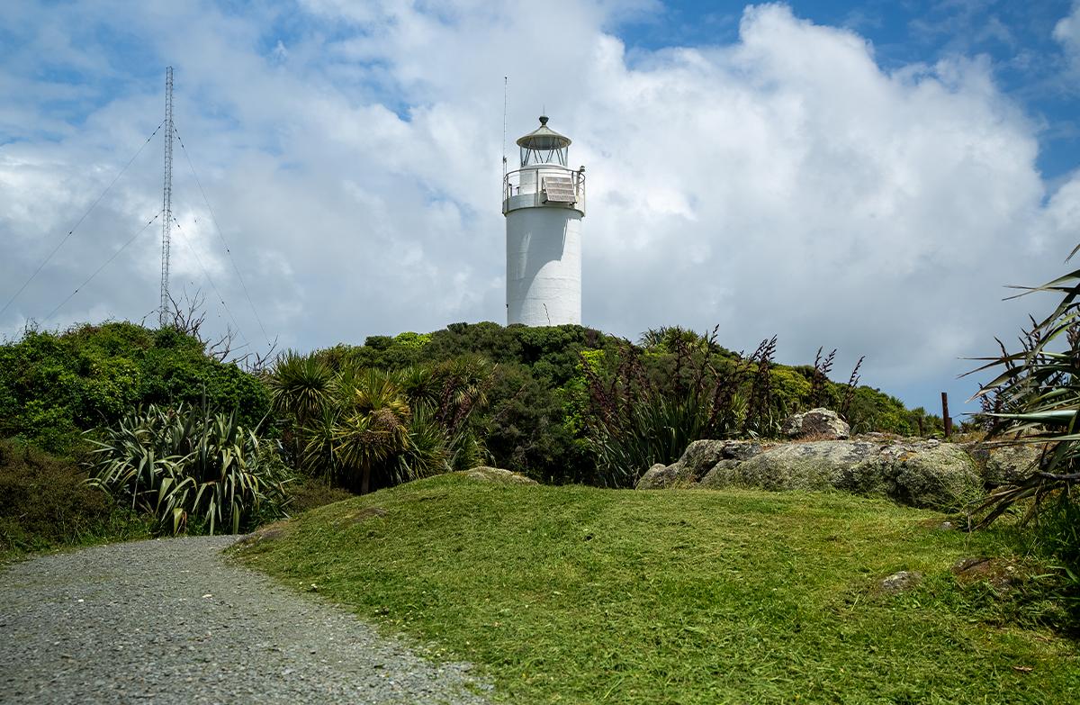
Coastal views and historic lighthouse
Wheelchair-accessible option
Cape Foulwind Walkway leads to one New Zealand’s most accessible seal colonies.
Enjoy spectacular views of the coast and mountains. On a fine day, you can see:
south to Aoraki/Mount Cook
north toward Kahurangi National Park
inland to the Paparoa Range.
Information panels along the track tell stories of Māori history, sea voyages and early explorers.
You can walk Cape Foulwind Walkway from either end. Most people start at Tauranga Bay.
The track from Tauranga Bay to the seal colony is suitable for wheelchairs and buggies.
Tauranga Bay car park to seal colony viewpoint
30 min / 1 km (return) Wheelchair-accessible short walk
From Tauranga Bay car park, follow the signs to the seal colony viewpoint.
Take the short side track to Wall Island lookout for views of the small rocky island just offshore. It’s home to a large population of seabirds.
Continue to the seal colony viewpoint. New Zealand fur seals/kekeno live at the Cape Foulwind seal colony year-round. During the summer breeding season, it’s full of playful seal pups.
The track is gravel with some boardwalks. It’s mostly flat or gently sloping, with some steep sections.
Return to the car park the same way you came, or continue to Cape Foulwind.
Tauranga Bay car park to Cape Foulwind lighthouse
2 hr / 5.8 km (return) Easy to intermediate walking track
From the seal colony viewpoint, follow the signs to Cape Foulwind.
You’ll walk above the rugged coastline and through New Zealand flax/harakeke to the Cape Foulwind lighthouse lookout. Get stunning views out to the Tasman Sea and rocky islets known as The Steeples.
From the lighthouse, it’s another 15 min to Cape Foulwind car park. You can:
arrange to be picked up
retrace your steps to Tauranga Bay
return via Kawatiri Coastal Trail.
No mountain biking
Mountain bikes are not permitted on Cape Foulwind Walkway.
Getting there
Cape Foulwind Walkway is 15 min by car from Westport.
There is a car park at both ends of the walkway. Start at Tauranga Bay for the seal colony, or Cape Foulwind for the lighthouse.
Tauranga Bay car park
From Westport, take SH67 over the Buller River and turn right at the junction with Cape Foulwind Road (SH67A). Continue for 11 km.
Turn left onto Tauranga Road at the coastal settlement of Omau. From here, it’s 5 km to Tauranga Bay car park.
Open in Google Maps
Tauranga Bay car park has:
free parking for cars and campervans
two marked mobility spaces.
Cape Foulwind car park
Follow the same directions as for Tauranga Bay but at Omau, turn right onto Lighthouse Road. From here, it’s 1 km to the Cape Foulwind car park.
Open in Google Maps
Cape Foulwind car park has:
free parking
two marked mobility spaces.
Kawatiri Coastal Trail
Kawatiri Coastal Trail provides walking and cycling access to Cape Foulwind Walkway. The Omau section of the trail runs inland from the walkway, linking the car parks at either end.
Kawatiri Coastal Trail
Know before you go
Mana whenua
Ngāti Waewae hold mana whenua or customary authority over this special place.
Safety and hazards
Steep drops: Parts of the track are exposed. Stay away from track edges and keep children close.
Seal colony: Seals can be aggressive. For your safety and theirs, view the seal colony from the viewing platform only.
Wasps: Wasps and wasp nests may be present. Bring antihistamines if you are allergic to wasp stings.
Plan your visit
Bookings are not required for Cape Foulwind Walkway.
Toilets and an accessible toilet are located at Tauranga Bay car park. Toilets are also located at Cape Foulwind car park.
Drinking water is not available. Bring your own.
Picnic tables and a small shelter are provided at Tauranga Bay car park, and a picnic table at Cape Foulwind car park. There is seating at the seal colony viewpoint.
Food and petrol are available at Westport (15 min by car).
Mobile phone coverage is unavailable in places.
When to go
The best time to see the Cape Foulwind seal colony is during the breeding season, between September and February.
Cape Foulwind Walkway can be enjoyed in any weather. It’s exhilarating in a storm, and spectacular on a fine day.
New Zealand weather changes quickly. Check the weather forecast before you go, and be prepared.
View weather forecast
Be prepared
What to take
Sturdy footwear
Warm and waterproof clothing
For a complete list, see Short Walks gear list.
Care for nature
Rubbish bins are not provided. Take your rubbish with you.
New Zealand fur seals are protected native animals. Stay at least 20 m away and keep dogs on a lead.
Protecting nature in Aotearoa
What to do if you see a fur seal
No drones
Flying a drone without a permit is strictly prohibited.
Drone use on conservation land
Nature and conservation
Seal colony
The seal colony at Cape Foulwind is home to New Zealand fur seals/kekeno year-round. It’s one of six breeding colonies on the West Coast.
Cape Foulwind is an ideal place for fur seals to live and breed. The rocky shoreline has lots of places for them to come ashore (called ‘haul-outs’), and the sea is rich in food.
New Zealand fur seals/kekeno
Seabirds
Cape Foulwind and its offshore islands are home to breeding populations of:
fairy prion/tītī wainui
red-billed gull/tarāpunga
black-backed gull/karoro
white-fronted tern/tara
sooty shearwater/tītī
little penguin/kororā.
Australasian gannet/tākapu and spotted shag/parekareka can also be seen in the area.
New Zealand birds A–Z
Marine mammals
Hector’s dolphins and orca are sometimes seen off Cape Foulwind Walkway.
History and culture
Sheltered anchorage
Ara tawhito are traditional travel routes. They lead up and down Te Tai Poutini/the West Coast, providing access to pounamu/greenstone and abundant mahinga kai/food-gathering places.
Tauranga Bay, south of Cape Foulwind, was an important place on this coastal route. It was a sheltered anchorage for waka/canoes and a resting place for people travelling by sea and land.
A place of foul winds
Dutch explorer Abel Tasman sailed past Cape Foulwind in 1642 and named it Rocky Point. Tasman was the first European to set eyes on Aotearoa, but he never stepped ashore.
In 1770, British explorer James Cook’s ship, the Endeavour, was beset by gales here. Cook described it as a ‘place of foul winds’ – the origin of its English name today.
Cape Foulwind lighthouse
A timber lighthouse at Cape Foulwind was first built in 1876. Its beacon guided ships on the difficult approach to Westport Harbour for 50 years.
A concrete lighthouse with an automated light replaced the original lighthouse in 1926. It still operates today.
Sources and reuse
Route descriptions and practical information reproduced from the Department of Conservation, Crown copyright, under CC BY 4.0, subject to DOC's copyright policy. Formatting has been adapted, including flattening page sections; follow the original DOC page for maps, section-specific layout, current notices and linked documents. Outdoor Next is independent and is not endorsed by DOC.
The accompanying photograph is published in DOC's official route gallery with an explicit reuse licence. Its original caption and credit are retained; it does not establish current track conditions.
