By Outdoor Next Editorial standards
On this page
Key facts
- Distance
- 46 km one way
- Walking time
- 1 - 2 days
- Track grade
- Advanced
- Location
- Tongariro Forest Conservation Area
- Seasonal restrictions
- 4WD vehicles are not permitted from 1 May – 30 November.
- Dog access
- Dogs with a DOC permit for recreational hunting or management purposes only. Other pets on conservation land rules.
Checked against official sources on 8 October 2026. Rules and conditions are set by Department of Conservation — confirm with them before you go.
Route overview
The 42 Traverse is a challenging multi-use 46 km track through the Tongariro Forest Conservation Area.
This DOC directory entry covers 42 Traverse in Central North Island, within Tongariro Forest Conservation Area. Where DOC groups several walks, times and grades refer to the listed options rather than a single continuous itinerary.
Distance, time and grade
- Distance: 46 km one way
- Walking time: 1 - 2 days
- DOC grade: Advanced
Access and alerts
Source checked 2026-10-08. This page is a dated snapshot, not a live track-status report. Check current DOC route information immediately before travelling. An absence of listed alerts does not establish that a route is open.
- Slip on the 42 Traverse; First published on 18 September 2024. Last reviewed on 29 September 2026.
Seasonal restrictions
4WD vehicles are not permitted from 1 May – 30 November.
Dog access
Dogs with a DOC permit for recreational hunting or management purposes only. Other pets on conservation land rules.
Description
The 42 Traverse is a challenging track best suited to experienced, well-equipped people. It leads through fantastic native forest and the awesome Canyon valley. There are superb views back to the volcanoes of Tongariro National Park.
The route is an old logging road that gets its name from the original 'State Forest 42'. It is popular for a range of activities: mountain biking, quad and trail biking, four-wheel driving (summer only), horse riding, fishing, hunting and hiking.
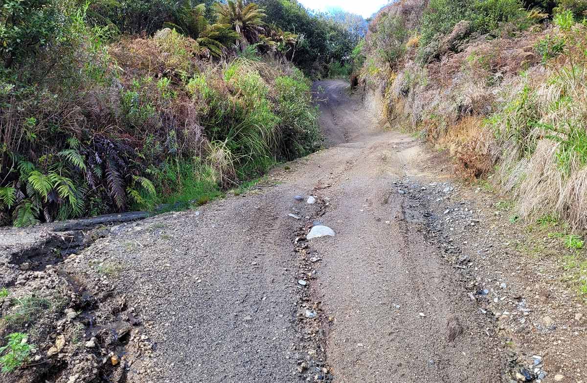
The area is remote and there are often slips, fallen trees and other damage on the track. Sections of the track are very technical. Read the Know Before You Go section carefully for information on what to pack and expect.
The 42 Traverse route: from Kapoors Road to Ohinetonga Road
The track can be used in either direction. However, it is easier for walkers and bikers to go from Kapoors Road to Ohinetonga Road, as there is more downhill that way.
The track starts at the end of Kapoors Road, off SH47. The track leads north. There are many intersecting tracks and old logging roads. Look carefully at intersections and make sure you are staying on the right route. Carry a map and other navigational aids (like a GPS and compass) to help you.
The track descends and crosses Waione Stream. After climbing out of the valley, you reach the bypass track, which takes you past a major landslide (more info below). The 42 Traverse Track then continues on past Mako Stream then eventually turns into and ends at Ohinetonga Road. This unsealed road leads into Ōwhango town.
There are multiple unbridged stream crossings on this track. These can rise rapidly after rain and may not be safe to cross. Assess them carefully before crossing and if in doubt, stay out.
The 42 Traverse is part of Te Araroa from the Ohinetonga road end to Waione Stream. There is a track junction near the Waione Stream – this is where Te Araroa walkers turn off the 42 Traverse Track and onto a tramping track.
Track bypass around large landslide
There is a large landslide on the 42 Traverse Track. Do not attempt to cross the landslide. It may still be unstable.
There is a bypass track around the landslide for walkers and cyclists. There is limited signage – use GPS for navigation.
Cyclists should dismount their bikes for the bypass section as it is steep and slippery.
There is no bypass for 4WD vehicles, quad bikes or motorbikes.
The bypass is not recommended for horse riders, they should return the same way they came in.
42 Traverse bypass track map (PDF, 3,326K)
Mountain biking
The route is through a remote area, and it is technically challenging. There is no easy way out once you start. You should not attempt the trip unless you have good fitness and experience.
There are giant climbs, narrow track and numerous hazards including dangerous drop-offs, sharp corners and difficult obstacles. Expect to walk some sections and possibly bike carrying.
Four wheel driving
The track is open to 4WD vehicles each year in the summer from 1 December – 30 April. 4WD vehicles are not permitted from 1 May – 30 November. Vehicles are not permitted off the 42 Traverse route.
It is a rough 4WD track – always take recovery gear with you. You need good 4WD skills and experience, as well as the equipment to be self-sufficient.
Take care following rainfall as stream levels rise quickly. Only cross waterways after checking they are safe.
Getting there
About 16 km along SH47 from National Park Village, turn into Kapoors Road. Follow this for about 6 km to the start of the track at the road end.
Know before you go
Expect a challenging track
Make sure you have the skills and experience for it. People have had accidents and got lost on this track.
These are common on the 42 Traverse:
Very slippery and muddy track in places.
Slips happen regularly and can occur at any time. They may make the track impassable.
Fallen trees blocking the track.
Intersections/junctions without signs, where you need to check the map and correctly identify the way to go.
Holes in the track.
Deep ruts in the track.
Obstacles and loose rocks.
Steep banks/drops next to the track.
Multiple users of the track, including vehicles, bikes, horse riders and walkers. It may be hard to see other users, e.g. due to blind corners.
Unbridged stream crossings, which can flood and become impassable during and after heavy rain. If they are flooding, turn back or wait for water levels to drop to a safe level before crossing.
There are many intersecting roads/tracks which can make it difficult to navigate. Look carefully at intersections and make sure you are going the right way. Always carry a map, other navigational aids (for example: compass and GPS) and a distress beacon.
If you see any major damage on the track, report it to the Tongariro National Park Visitor Centre (tongarirovc@doc.govt.nz, +64 7 892 3729).
Pack for a backcountry adventure
This is a remote backcountry area. Pack warm, waterproof clothes, plenty of water, spare food, a torch (plus spare batteries), sun protection, a map and compass or GPS, first-aid kit and other emergency equipment. Cell phone reception is patchy, so we strongly recommend carrying a distress beacon or other satellite communication device. Day hikes packing list
Mountain bikers will also need a safety helmet, puncture repair kit, spare brake pads, eye protection, tool kit and a spare tube.
People driving 4WDs should bring recovery equipment.
The track is shared by different users
The 42 Traverse has a variety of users -– share the track with care and consideration. People drive, ride and walk in both directions. Go slow around corners and be ready to give way to other users.
Stay safe when crossing rivers and streams
If you plan to cross unbridged rivers or side streams, know how to cross safely and be prepared for if you cannot cross.
Do not cross if the river or stream is flooded, you cannot find safe entry and exit points or are unsure it’s safe. Turn back or wait for the river to drop. If in doubt, stay out.
How to cross rivers safely
NIWA river flow forecasts: View a video of national followed by regional river flows
Sources and reuse
Route descriptions and practical information reproduced from the Department of Conservation, Crown copyright, under CC BY 4.0, subject to DOC's copyright policy. Formatting has been adapted, including flattening page sections; follow the original DOC page for maps, section-specific layout, current notices and linked documents. Outdoor Next is independent and is not endorsed by DOC.
The accompanying photograph is published in DOC's official route gallery with an explicit reuse licence. Its original caption and credit are retained; it does not establish current track conditions.
